I updated this page and closed it on January 21, 2013, then did a light edit on 1/11/2015. Please see 2013 - 2014 for more great stories!
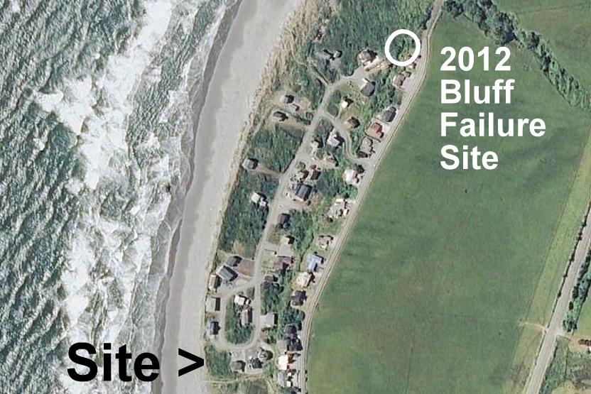
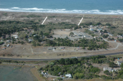
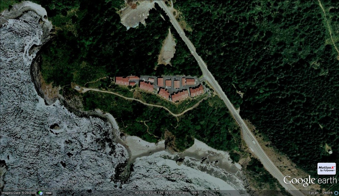
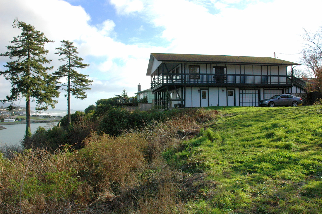
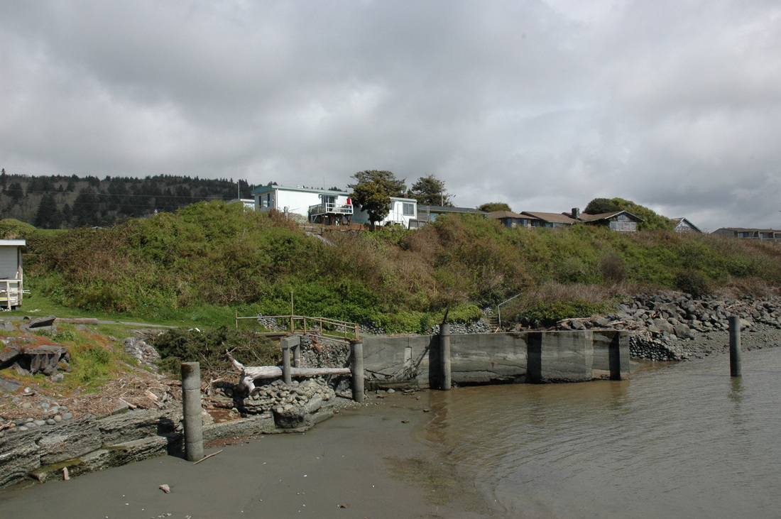
#12-038. HOW IMPORTANT IS 37% RISK IN THE NEXT 50 YEARS? The answer, it turns out, is a function of how each of us perceive risk. The current risk assessment by the geoscientists in the field is that there is a 37% chance that the Cape Mendocino, CA, to Newport, OR, segment of the Cascadia subduction zone will rupture generating an 8+ M earthquake within the next 50 years. A devastating tsunami will follow within about 15 minutes. So should the owner of this lower elevation Rogue Shores lot in Gold Beach, OR, build? Should the County (or State) allow it? Should an insurance company or FEMA insure the home? Or be allowed to insure it? These questions become more thorny as the clock ticks down to the next Csz event. The latest deep sea core data suggests that the mean recurrence interval of southern segment events is 240 years. The last one happened at ~9:00 PM on January 26, 1700. We're "overdue" (by 74 yrs and counting). We completed our geologic hazards and risk / foundation soils report for this lot. The owner plans to build and to reduce the risk of damage by non-catastrophic hazards as possible. P.S. A photo of the 2012 bluff failure site is entry #12-018 below.
#12-043. ANOTHER STORM-DAMAGED PROPERTY IN BROOKINGS. This landslide in the Mountain Drive area of Brookings, Oregon, happened a few days after the 6"+ rainfall event mentioned below. More rain had fallen and, additionally, time had elapsed. Time allows groundwater to percolate ever lower down a hillslope so sometimes slides happen hours or days after a large rainfall event. This (like the slide in the photo below) is a debris slide scar. The headscarp is 30 ft or so from the home, the scar is only a few feet deep, and the home is not in danger. About 50 feet of debris (topsoil and brush) decoupled from the steep hillslope, slid, and then flowed about 200 ft downslope. Water from springs downslope carried "fines" another ~200 ft down an old skid trail to a raging tributary of the Chetco River. There were two more debris slides (that I know of) within about 500 feet of this one. We completed a risk assessment for the owner to support a possible future sale of the property.
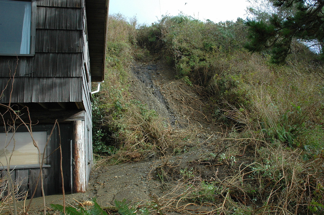
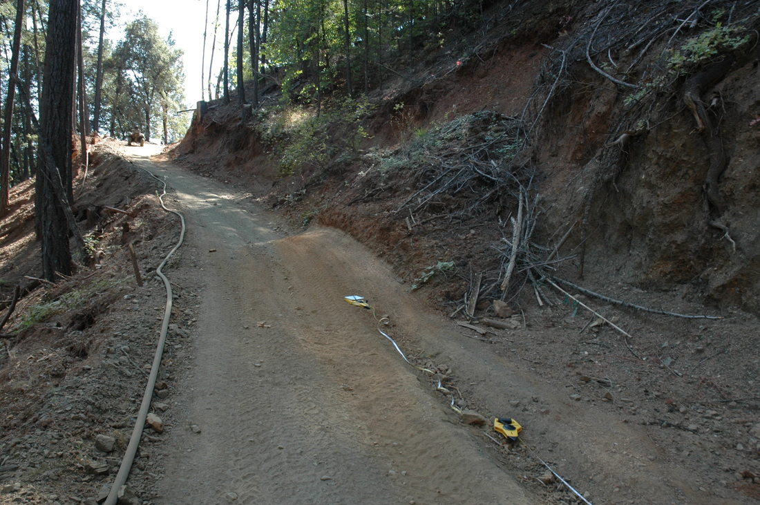
#12-040. 6 to 7+ INCHES OF RAIN IN 10 HOURS is a lot of rain when 5" in 24 hours is enough to trigger landslides on many steep slopes. This debris slide in Harbor, OR, occurred during the wee hours of a November 20-21 deluge that caused the Chetco River to rise to its highest level in 30 years or so. This slide, others, sink holes, road collapses, and flooding of low-lying residences were part of the consequences. Our client hired us to determine what caused this slide, if it would grow, and what to do about the debris (it is piled up against the cabin wall). Our inspection revealed that a drainline from the upslope neighbor's roof discharges onto the top of bluff directly above this slide, suggesting that residential water was a primary causal factor. Preliminary calculations (involving many assumptions) suggest that the drain dumped a minimum of 24,000 lbs of water onto the head of the slope. That, plus groundwater emerging under hydraulic head from a gravel layer on top of the bedrock, caused an initial failure of a large mass of soil on the upper part of the slope followed by enlargement of the initial scar and erosion of the face by raindrop impact and running water. We wrote a report for our client to send to the neighbor and cabin co-owners so that repair / stabilization costs can be shared.
lick here to edit.
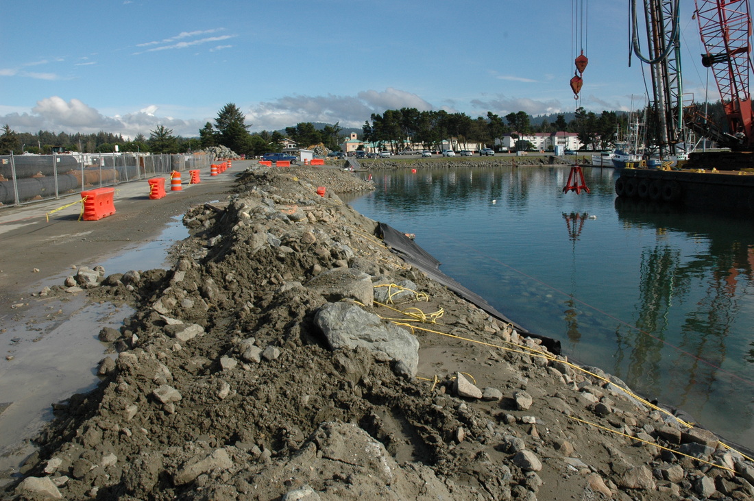
#12-034. IS THIS THE RIGHT STUFF? Part of the harbor rebuilding project in Crescent City, CA, due to the damage from the March 11, 2011, Tohoku, Japan tsunami, involves removing the existing riprap, excavating back into the parking lot, laying a cobble bed, covering it with geotextile, and then placing boulder riprap (11 ft thick!) on the fabric. The lower portion of the boulder riprap is visible just below the water's surface. Our job is to evaluate the spoils--the material being removed--to determine if it can be used to extend the Crescent City airport runway and be used in new roadways. This photo shows the material: slightly silty fine sand mixed with angular cobbles and boulders, gravels, and trace bioclastic (shell) debris. We sent the matrix sand to an outside lab (Cooper Testing Laboratory in Palo Alto, CA) for a specific test to determine the material's bearing strength (CBR). Our report provided an estimate of the percent-rock, evaluated the texture of the fines, and provided options for using the available materials. It turned out that it's NOT the right stuff.
#12-024. IS CHANGING A FORESTED DUNE TO A BARE DUNE "RESTORATION?" Our client thinks not. We agree. Note the dune area between the two white lines; it is more bare than the adjacent areas. Especially notice the lack of trees. The group responsible for caretaking this area of the Manila dune field (with grant money) has weed-whacked away plants that maintained a micro-environment that kept trees alive. We are wondering if a review of sequential pairs of historic aerial photographs will demonstrate that the "management" of this part of the dune field has been the kiss of death to the trees that formerly grew in this part of the field. [To see a spectacular aerial photograph of the much larger dune field, upload the free Google Earth program, type "Humboldt Bay, California" in the search field, and then "fly" down low over the northern barrier sand bar that separates the bay from the Pacific.]
#12-037. DUELING NEIGHBORS / DYNAMIC CREEK, Northern California. This is going to get messy. We've been told--but have not verified--the following tale. Some years ago residents living north of a creek mouth stacked rocks along the north bank to divert the stream to the south. It worked. The stream ate into the toe of the then-vegetated sand and gravel bluff. The result over the next few years? An estimated 1000 cubic yards of cliffside fell into the estuarine part of the stream in a series of ongoing failures, choking the channel with more debris than it could remove. Our client, the owner of the land above the creek bluff, worried as he watched the failures continue to eat into the top-of-bluff lot. So, in true John Wayne style, he had an excavator move driftwood from the north side of the channel toward the base-of-bluff to create a new channel more-or-less back where it used to be (visible in the photo). Needless to say, regulators (and the neighbors) had something to say about that. Strangely, the same authorities apparently didn't have anything to say when the same neighbors did the work that led to the cliff failures. And we hear the neighbors are illegally sand bagging the north side of the channel, again trying to force the stream south. This is going to get messy. Our goal is to support our client as possible by being able to assess the magnitude of the cliff failures, the nature and significance of the materials the excavator moved, and the record and timing of cliff failures (by reviewing stereographic pairs of aerial photos). And no, we're not saying where this is. (See the "Oops" section of the Photo Galleries for more photos.)
#12-029. UPDATE: DOES THE FLOOR OF YOUR BANK LOOK LIKE THIS? This is a follow-up photo of our work on the North Valley Bank in Garberville, CA (see #12-002 photo below). Eight or nine images below this one is a photo of the same floor looking across the location of this trench. A contractor excavated this trench for us (during business hours!) so we could evaluate the soils conditions and try to determine why the floor cracked in the first place. Unfortunately, everything is not black and white in this business: we, a concrete specialist, the contractor, and an engineer could not determine precisely what active process had cracked (and purportedly still was cracking) the floor. We did discover roots up to an inch in diameter (from a tree 40+ feet away), and we did determine that whatever the actual cause, the real problem is the poor construction of the decades-old slab: it contains no rebar, varies in thickness, has voids, has no underlayment, and contains cobbles larger than the slab is thick! Our final report recommends that the bank build a new structural slab on top of the existing slab and its flooring, and that a system of short cast-in-place concrete piers bearing on competent native soils support the new slab. The bank is hiring an engineer to design the new floor.
#12-033. TOO STEEP? The steepness of this Harbor, OR, lot constrains the development options. A daylight basement / living space...a cutpad with a retaining wall on the upslope side and cast-in-place piers for the downslope foundation...maybe a drive-in garage with an elevator to second-story living quarters. These are the kinds of options the owner / builder has to choose from. As a note, the trunks of mature conifers upslope of the lot, ones growing on a similarly steep slope, are swept (bowed) to 20 to 30 feet above ground. This indicates that the ground the trees are growing on is creeping (plastically deforming) to greater than typical depths. As a first step, we've recommended a topographic map followed by representative cross-sections showing different development possibilities. The owner is thinking.
#12-031. CAN THIS ROAD BE SAVED? Our client, a Junction City, CA, resident, pioneered this road across a marginally stable hillslope 2011 to avoid using a neighbor's road to access the upper part of his property. The dozer operator evidently was "old school" and didn't build the road using today's erosion-aware techniques. Logs covered with sidecast dirt line much of the outboard edge of the road (here, the left side) and the cutbank is too steep for the soil type (creeping rocky soils). This photograph shows a 10-cubic-yard (+/-) slide onto the insloped road travelway as well as a berm (low pile of soil) on the outboard edge. CAL FIRE would prefer to see the road closed, but it might be possible to save it for use by ATVs. California Geologic Survey engineering geologists and CAL FIRE regulators reviewed it favorably. Our client must complete the necessary erosion-control work but he can maintain a narrow ATV access to the slopes above.
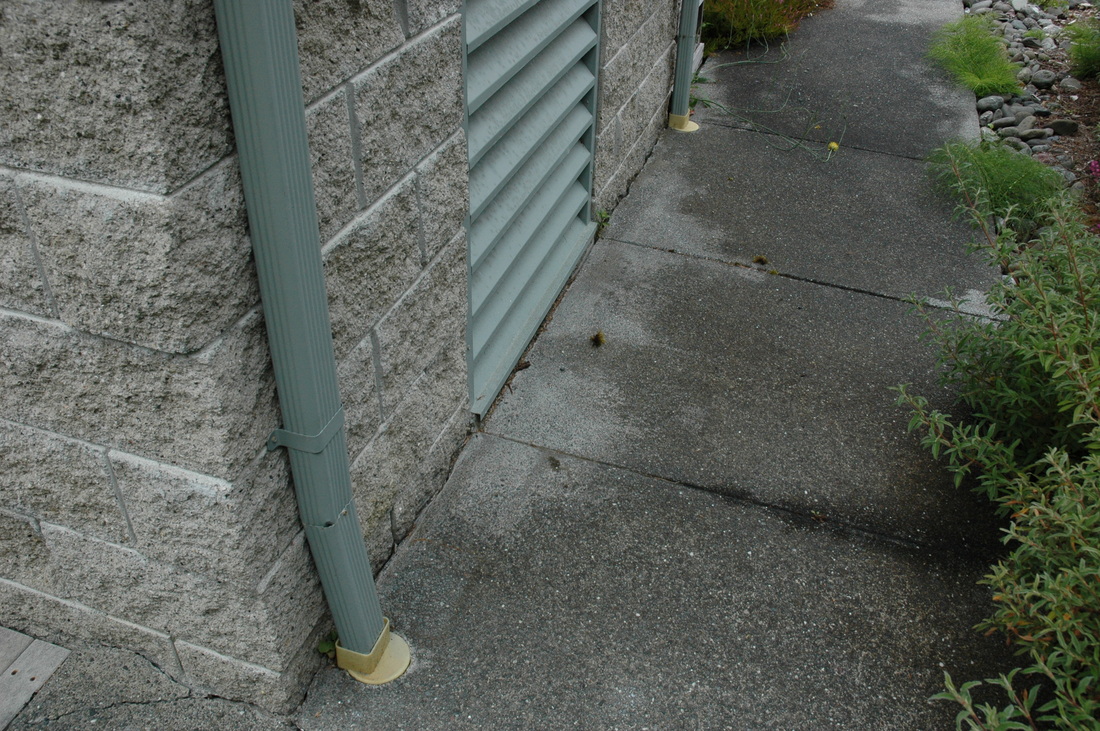
#12-025. TO WORRY OR NOT TO WORRY, THAT IS THE QUESTION. This photograph shows the east edge of a concrete block generator building that sits on the top of a scarp of a slump in the west edge of the backyard of a million-dollar home north of Trinidad, CA. In 2004 when we inspected the property for a potential buyer, the sidewalk abutted the building. In September 2012 when we again inspected the property for a new potential buyer, we noticed that the south (nearest) end of the building was separated from the walk 0.1" but the north end was separated 0.6". If you look closely you'll notice that the south gutter downspout kicks out as it enters the plastic connector, but the north downspout is nearly plumb. The difference in the gap was caused by the slight rotation of the building toward the southwest. Not surprising, other factors (notably, landforms and knowledge of the area geology and history) make us believe that there is an active landslide off to the southwest. But is it growing or not? Monitoring using tiltmeters probably would give us the answer. We're hoping that the new owners will hire us to monitor the building and attached large deck. Regardless, time will tell.

#12-008. A SUBDIVISION ACCESS ROAD UNDER CONSTRUCTION! The developer of the Trillium Creek subdivision in Arcata, CA, has been busy this summer building the subdivision road entrance--an extension of Ridge Road--using a mixture of 65% recycled concrete and 35% other soil (imported sand or native subsoils from site excavations). He and his assistant had this stretch of the road done and winterized before the 2012-2013 winter rains arrived.
#12-017. IS THERE AN INEXPENSIVE WAY TO FIX THIS? A large mobile home park south of Eureka, CA, experienced a road edge failure. To understand the cause of the failure and the subsurface conditions, and to determine which of the possible repair methods would be cost-effective over the long term, BGC geologists (here, Mark Tennyson) mapped the damaged road area, hand-augered boreholes into the slope, sampled and tested soils, determined the groundwater table elevation and soil moisture conditions, and profiled the slope in several locations. (The hillslope is composed mostly of interlayered silty and clayey fill soils that dip downslope and overlie a thick layer of buried native topsoil. However, the cause of the road edge distress appears to be an existing drain composed of angular cobbles. The large mass of cobbles surcharged the top edge of the hill causing the moist-to-wet weak soils to plastically deform. That caused the cobble mass to pull away from the fill, settle, and crack the asphalt pavement.) The Elk River flows at the base of the slope. Our final report recommended using stacked geofoam (which weighs about 2 pcf) to replace the failing soil mass (which weighs about 120 pcf) in order to take the surcharge load off the top of the hill. The Division of State Lands approved our report and issued a permit. A contractor completed the construction in early January, 2013 (see 2013 Jobs and Case Histories for photos of one of the regions first geofoam projects).
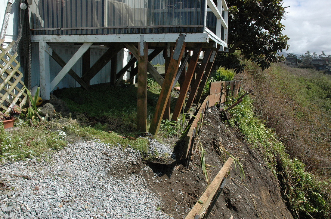
#12-019. WHAT TO DO NOW? The owner of this 60+ yr-old Trinidad, CA, home watched this subtle warp form in the ground over the past few wet winters. The home was damaged structurally (contained foundation cracks and significant carpentry repairs) when he purchased it, and now it is ~14" out of level. The block of ground west of the dashed line is sinking, down-toward-the-ocean, and the future longevity of the home is at question. Cracks extend throughout the entire home and garage, so more ground than just the part in the down block is moving. If the California Coastal Commission will not let him upgrade the foundation (because of the CCC requirement that a repair should have a 75-yr economic lifespan), should he redesign the home and move it back (and lose a spectacular view)? We completed a floor-level survey map, geologic cross-section to the beach below, and a limited-scope report. An engineer drew up a preliminary foundation repair plan, a contractor gave the owner a foundation repair estimate, and now the owner must decide what to do. We don't envy his position.
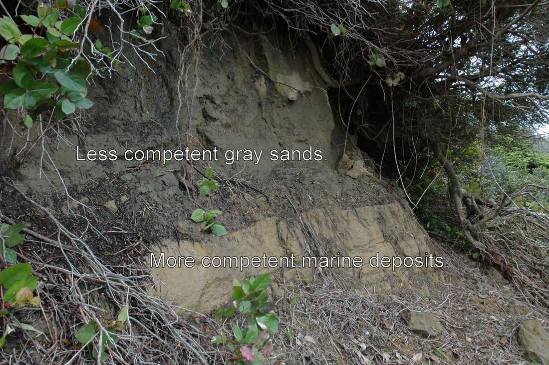
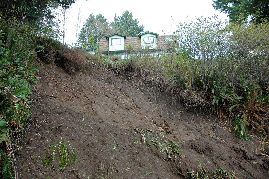
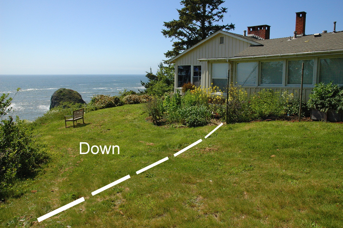
#12-018. IF THE HOME IS BACK JUST 7 TO 10 FEET FROM THE BLUFF TOP, IS IT SAFE? That's the question our client, a potential buyer of the home above this slide, asked us in May. A March landslide on the bluff face below the home worried the seller and potential buyers alike. We were hired to evaluate the risk to the home, whether stabilization of the landslide or home (two different things) is necessary, and if an addition is possible. The landslide exposed several geologic units of differing stability and competency. We completed a report for our client, who chose not to purchase the home (for reasons unrelated to the landslide), and we have consulted with several other potential buyers for the seller. (The opening photo of this page (for job #12-038) shows the location of this landslide on an aerial photo.)

#12-002. STRUCTURAL DISTRESS? CARPENTRY ISSUES? SOIL BEARING PROBLEMS? ANY CHANCE OF GROUNDWATER PIPING? In February we began an evaluation of the cause of the settlement, warping, and cracking of the floor in a many-decades-old building occupied by a bank in Garberville, CA. A floor-level map revealed an interior topographic high paralleling an outside wall. Exploration revealed a crack. After issuing a preliminary report we researched the location of storm drains and water and sewage lines. Subsequently we did a Phase 2 investigation that led to a recommendation to replace the floor by building a new slab on top of it. (See photo for job #12-029, above.)
#12-005. SEPTIC SUITABILITY. 2012 was the third year of a septic suitability study of a property east of Trinidad, CA (the "third year" because the prior owner of the property "drug his feet." This job number doesn't reflect prior contract numbers.) Septic constraints in the three-acre property include missing-to-thin topsoils, clayey subsoils, high groundwater, near-surface bedrock, slopes over 30%, setbacks from property lines and cutbanks, downed timber, run-off from a neighbor's driveway, and difficult access for equipment. In 2012 we made a last-ditch effort to find a suitable leachfield area and design solution. Unfortunately, we had to advise the property owner that the land cannot support a sewage disposal system of any type currently permitted by the Humboldt County Department of Environmental Health. Unfortunately, the owner has had to give up his plan to subdivide the parcel.

LONG-TERM MONITORING, SFR. We have been monitoring the stability of the ground seaward of a bluff-top residence above an unstable seacliff in Brookings, OR, since 2000, first with observations, then a tiltmeter array, then a slope inclinometer. We also are monitoring a complex set of cracks within a concrete stairwell in the home and cracks in the asphalt parking area along the bluff top. We update the owners regularly. The goal of the monitoring is to provide the owners with information to support their long-term planning and secondarily to understand what is happening in this marginally unstable bluff-top setting. Update: 1/2015: We are sorry to report that the owner passed away in late 2014. Someone purchased the home and presumably will tear it down and build farther back on the deep lot.
LONG-TERM MONITORING, CONDOMINIUM COMPLEX. In 1996 we began evaluating two multi-unit condominium buildings north of Brookings, OR, because of settlement cracks in the corner foundation of one of the units. We annually monitor two tiltmeters and a slope inclinometer set between two buildings and report to the complex's Board of Directors and Project Engineer. The results are proprietary.
#12-013. HOW "SAFE" IS US 101 SOUTH OF CRESCENT CITY FOR SUPER-SIZED TRUCKS? CalTrans is upgrading US 199 to facilitate use by super-sized trucks. We provided the Friends of Del Norte with landslide characterization and risk assessments for existing road failures on US 101 on "Last Chance Grade" between Wilson Creek and Cushing Creek and at several locations in the downhill approach to Crescent City. These are areas Cal Trans has not addressed in their project EIR for the US 199 upgrade. Report issued. Post script: After we issued our report CalTrans began extensive repairs on each of the critical areas we identified in our report (no causal relationship implied). Furthermore, the prolonged winter 2012 storm sequence triggered additional failures of each of the areas we addressed.

#12-009. DOES RUNOFF FROM A EUREKA PG&E YARD DRAIN TO HUMBOLDT BAY CARRYING TOXIC CHEMICALS? We helped Environmental Advocates, a San Francisco legal firm, trace the runoff from a PG&E yard to the bay using storm drain blueprints, topography analysis, and (we tried) ping-pong balls. We submitted photographic documentation to our client. T
#12-004. COULD A LANDSLIDE DAMAGE THIS RIVER-BLUFF HOME? We evaluated the condition of and risk to this decades-old home that was built too close to the top-of-bluff along the Chetco River and is now for sale. The owner will use our report to inform potential buyers of the geologic hazards and risks and ways they can minimize the potential for future damage. The report will help protect our client by disclosing the geologic concerns to potential buyers, thereby minimizing his risk of future litigation for "failure to disclose." Report issued. The owner has the home up for sale.
#12-012. WHAT GEOTECHNICAL DOCUMENTATION WILL UNDISPUTABLY PROVE THAT THE CONTRACTOR RESPONSIBLE FOR INSTALLING THIS "PARK MODEL" MANUFACTURED HOME FAILED TO PREPARE THE GROUND PROPERLY? The "Park Model" manufactured home supported by these pier blocks is dramatically out of level and contains stress cracks in the interior. The home's steel rails and other load-bearing members rest on concrete pier blocks that are leaning and shifting downslope as the uncontrolled fill they rest on breaks up and slides downslope, carrying the home with it. The ground beneath the home contains many open cracks and distinctly decoupled blocks of ground that have moved downslope, tilting the home supports that rest on it. The owner had to move out for safety. Now one pressing question is whether or not the home can be moved before it falls off its foundation. The ground has failed and the home has settled much more since we took this photo (see the next one). We provided verbal consultation to the owner, her family, and an attorney they retained.
#12-012. THIS IS A VIEW FROM INSIDE THE SAME PARK MODEL HOME AFTER THE PIERS IN THE PRECEDING PHOTO (AND OTHERS) TOPPLED OR LEANED MORE. Update: Our client settled favorably out of court and moved into a new home in Brookings, Oregon. The owners of the mobile home park still have a problem on their hands.
#12-014. HOW "SAFE" IS IT TO BUILD A LARGE BARN HERE? This gently sloping side yard in Hydesville, CA, belies the underground conditions: a trench and several backhoe test pits confirmed that the yard is a wedge of topsoil-based fill burying a thick native topsoil. The fill thickens to the right to about 10 ft deep, so the owner will minimize the risk of future damage by building as far away from the edge of the yard as possible and by using a deepened, strengthened foundation. Report Completed. Status of job progress unknown.
#12-015. IS THE HOME AT RISK? The face of a soil-covered sand dune bordering the Smith River sloughed off, exposing some of the piers of this deck. The owner was afraid the deck was unsafe and that the home was at risk as well. We inspected the site and determined that--for now--the deck is safe to enjoy, but that as soon as possible a contractor should support it using deeper piers or new piers set back farther from the edge. We suggested cost-effective alternatives for supporting the deck but also cautioned the owner that future failures of the topsoil are certain and that a strong earthquake could put the home at risk. Pro Bono Consultation Completed (but the owner sent us a Thank You check).
#12-015. A CLOSE-UP OF THE DECK SUPPORTS OF THE HOME IN THE PRECEDING PHOTO.

#11-035. WE DID THE GEOTECHNICAL STUDY AND CONSTRUCTION MONITORING FOR THE NEW REDWOOD OIL CHEVRON STATION AND REDWOOD MINI-MART IN McKINLEYVILLE, CA. The plan called for a new enormous underground gasoline tank, a building addition with a new shear wall, safety features, deeply embedded cast-in-place canopy and sign piers, and all new paving. Geotechnical Report and Inspection Reports Issued. The Chevron Station, mini-mart, and coffee shop are up and running.
#12-014. THAT BIG BARN IN HYDESVILLE...SHOULD THE OWNER WORRY ABOUT THE LITTLE SALMON FAULT BRANCHS BORDERING IT? Branches of the Little Salmon fault, a regionally significant, active thrust fault that also passes through the College of the Redwood campus, underlie the barn site at very shallow depth. A worst-case scenario is that a fault-rupture event could damage the barn severely (as well as the home). However, the law that governs construction on or near to active faults--the Alquist-Priolo Act of 1972--excludes structures like a barn, so construction is permissible at the owner's risk. See fault map below.
| hydesville.figure_2.pdf |
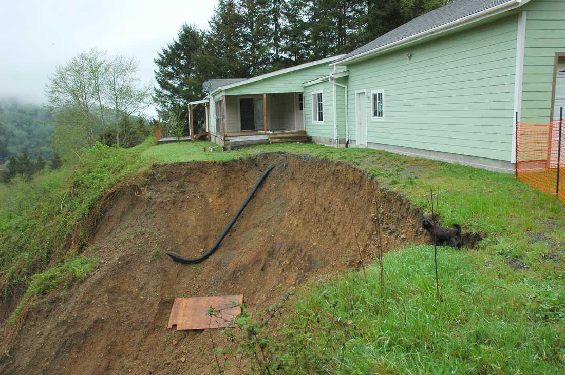
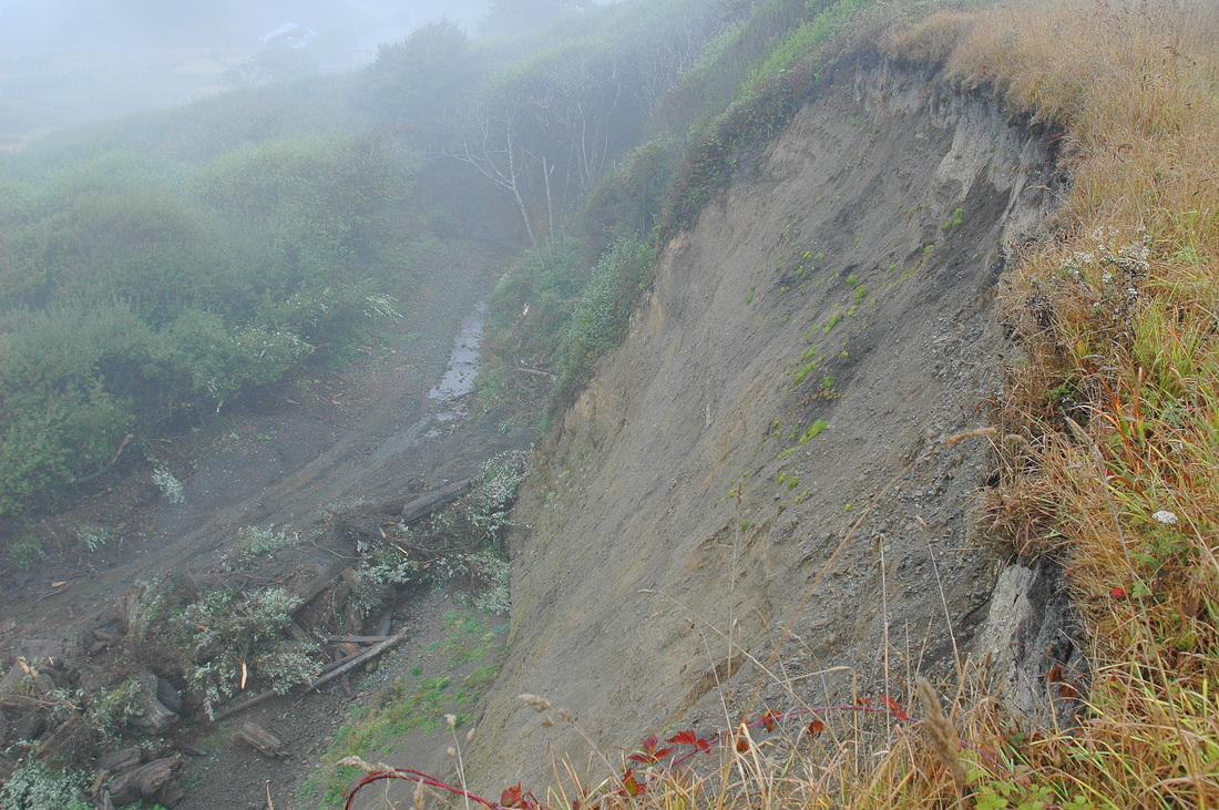
Proposal Only. BEFORE AND AFTER. The first photograph in the Website Photo Gallery Section titled "Oops" is a photograph of this same site taken in 2008, before the edge of the site failed (during the 2011-2012 winter) as a catastrophic debris slide-debris flow. A comparison of the entire group of photographs taken in 2008 and 2012 indicates that the owners (who moved out) did not take any of the mitigative steps recommended in 2008 (such as diverting arriving driveway runoff). The home occupants did not hire us (or anyone) to complete an investigation, and now the mortgage holder must decide whether to invest in a geotechnical and engineering study that will determine if the building site can be saved and if so, how to do it. No job developed from our reconnaissance inspection of the site (done to prepare a proposal). Status of the home: unknown. The cute little black dog is a Brussels Griffon "geopup" named Doodle.
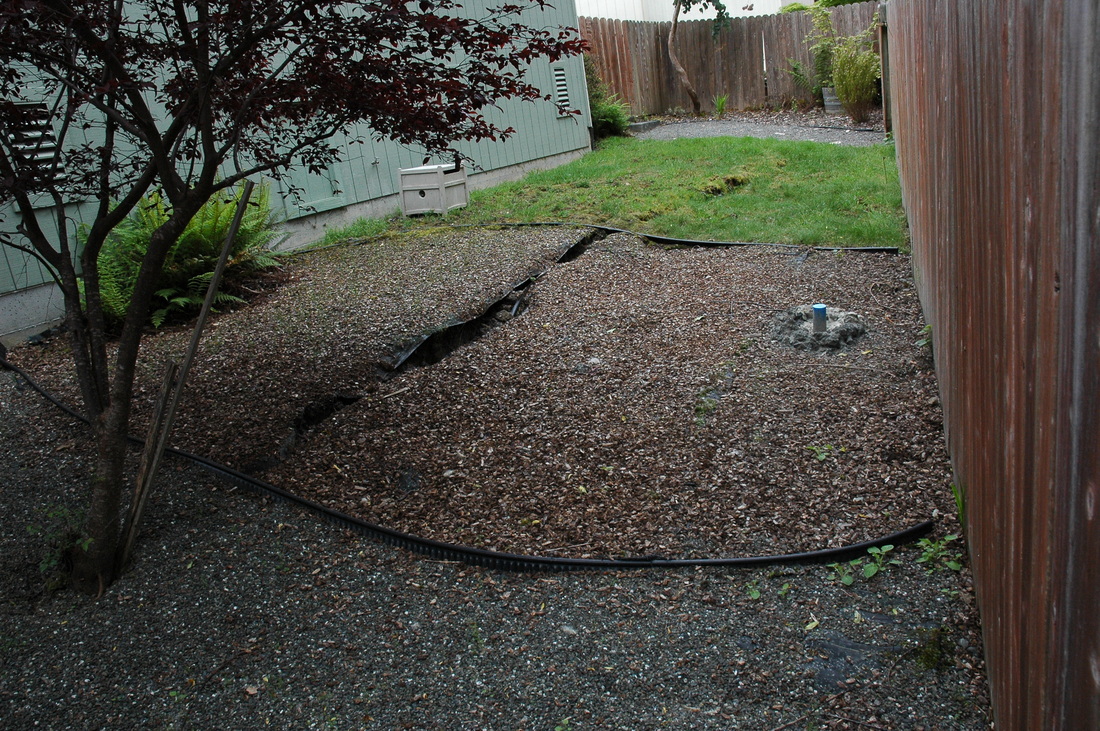
#12-016. IS THE LANDSLIDE NEXT DOOR GOING TO AFFECT MY HOME? A Eureka homeowner was worried that a landslide in the backyard of the home next door (photo), which extends onto her property, was going to cause her deck to collapse or the ground to fail. Our client, her insurance company, asked us to evaluate the situation. The black line is the head scarp of a landslide that extends onto the insured's property. The blue PVC pipe sticking up from the wood-chip-covered part of the yard is the top of a slope inclinometer casing that a competitor installed to determine the depth of the failure at that location. Report Issued. Update: The landslide continued to settle over the summer of 2012, so the scarp is higher. We have suggested planting deep-rooted trees on the small edge of the landslide that extends onto the insured's property.