Contact Information: Click on "Home," email [email protected], or phone 707-822-7300 (California) or 541-469-7300 (Oregon). Administrative inqueries to [email protected].
I last updated this page on November 8, 2013. I'll be additing additional case studies, but see Recent Work, 2012 and 2013. Those pages contain some great photographs and offer short encapsulations of in-progress or recently completed jobs.
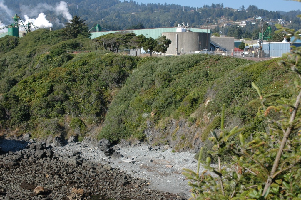
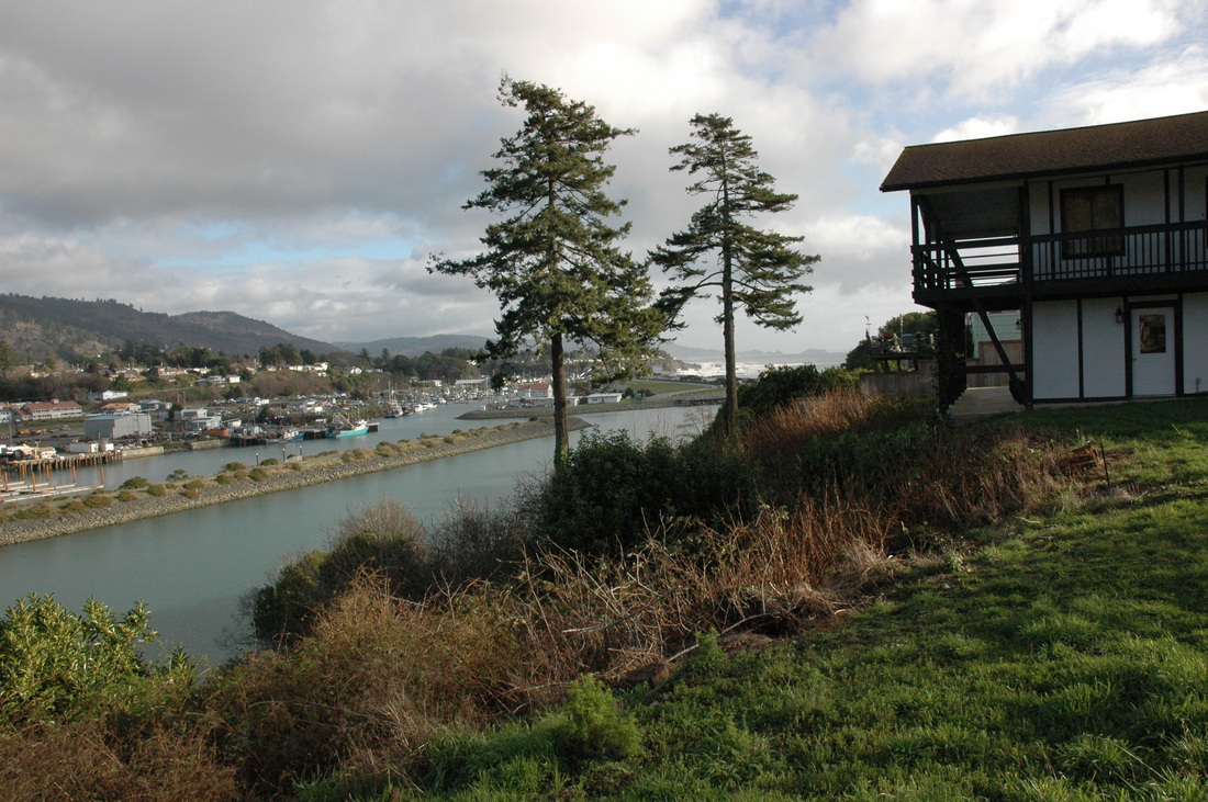
Rescuing a Waste Water Treatment Plant. In 2010 the City of Brookings, Oregon, hired BGC to determine the cause and significance of a series of discontinuous ground cracks that passed through the seaward edge of the waste water treatment plant. We completed geomorphic mapping, survey-controlled mapping of the cracks, geotechnical drilling, and slope monitoring using tiltmeters and slope inclinometers. We issued a preliminary report, final geotechnical report, and monitoring reports that supported funding applications, the engineering design of a bluff-top stabilization structure, and the relocation of selected facility structures. The effluent line has been re-routed away from the bluff edge, and a large soldier-pile wall will be constructed in 2014 if things go as planned.
Minimizing the Threat of Litigation. In 1997 the owners of a 17+-acre tract of oceanfront land near Sister's Rocks, Oregon, hired us to provide a "geotechnical realty disclosure report" (or "RDR" in our in-house lingo). The owners had planned to build but years later decided to sell the property. They wished to fully disclose the stability of the property to minimize their exposure to future litigation. Busch Geotechnical geologists completed topographic mapping, geomorphic mapping, a qualitative slope stability assessment, and the review of the original geologic report on the property and other pertinent information. We concluded that the risk to the property was higher than the original geology report had stated, that deep landslide failure planes were likely to underlie the probable building area, and that the prudent approach was to issue warnings and cautions as part of the report. Our client authorized us to issue a detailed report with numerous cautions. The property sold and the new buyer hired BGC to conduct the detailed studies we recommended in the RDR. We installed a tiltmeter grid (which determined that the shallow soils were actively creeping) and two deep slope inclinometers. Unfortunately, the data from the inclinometers confirmed our preliminary conclusion: a slide plane did underlie the proposed building area. Within three months of installing the inclinometers, one sheared off at 35 ft in depth. The other device lasted longer, and before we terminated monitoring, the data confirmed that a 20-ft-thick zone of soil (weathered bedrock) above the failure plane was deforming plastically (due to a type of slope failure known as earthflow). Disappointed, the new owner nevertheless proceeded with plans to build a structurally reinforced home on the slope. However, we recently heard that the property is for sale again.
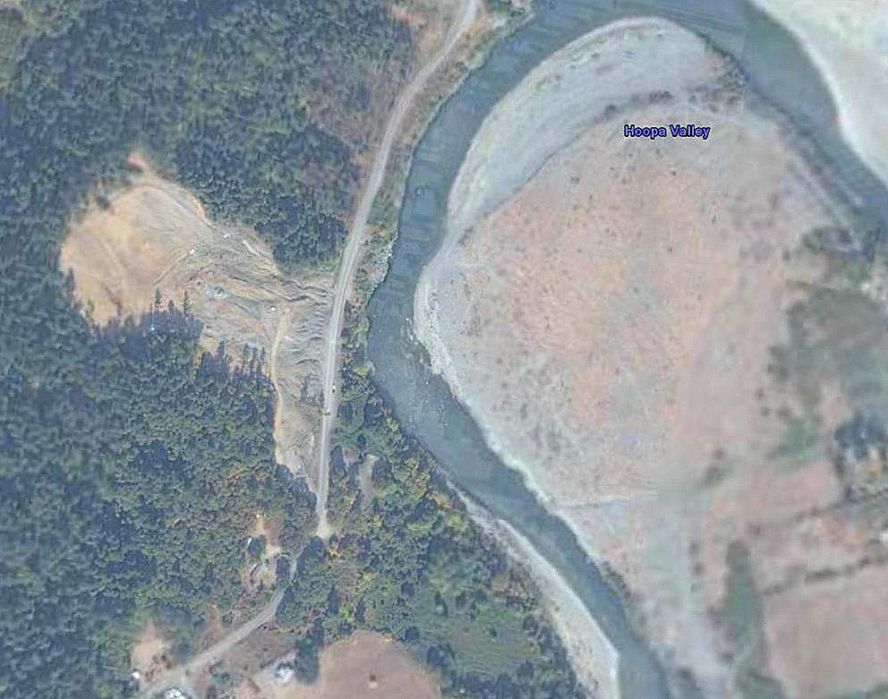
Stabilizing a Large Landslide. In 2005, Trinity Valley Consulting Engineers (of Willow Creek, CA) hired BGC to support the firm's attempt to manage a 25-acre landslide that threated to close an arterial road on the Hoopa Indian Reservation. A team of our geologists completed geomorphic mapping, plotting our findings on at TVCE base map. We supervised the drilling of six boreholes on the active landslide plus one above the head scarp and one below it. We installed slope inclinometers and since then have monitored them to chronicle movement--and lack of movement--of different areas of the landslide. As part of our work we wrote a report that became part of a document that tribal members took to Washington, D.C., to solict support for the stabilization of the landslide. Their trip to Washington was successful and as a result a massive grading project removed thousands of cubic yards of the most at-risk slopes. Mitigation of the landslide, as designed by TVCE with our support, involved grading, drainage control, localized slope buttressing, erosion-control work, and reforestation.

Too Many Fault Studies to Count. During the late 1980s, development activities in Humboldt County, CA., were nonstop. In 1972 the State of California passed an act that required developers of properties cut by faults that the State Geologist had mapped as "active" to have a registered geologist evaluate the land proposed for development. The Alquist-Priolo Act went into effect in the county in 1983 when the State first issued "Special Studies Zones" maps of the County. (These maps now are more appropriately called "Earthquake Fault Hazard Maps'). In 1988, Busch Geotechnical geologists supported by Humboldt State University geology students, worked on every significant fault in the county except the Little Salmon fault (which cuts through the College of the Redwoods Campus) and passes beneath the now-decommissioned Pacific Gas & Electric Humboldt Bay Nuclear Power Plant. That year BGC completed over 5000 feet of trench working on projects between Trinidad, CA, and Hydesville, CA. During that year and the succeeding ones, BGC geologists located fault traces on properties cut by the Trinidad fault, McKinleyville fault, and Mad River fault (east and west branches). We also identified locations that the fault, as mapped by the State, did NOT cross. Various logs record drag folds, displaced beds, bedrock thrust up and over younger marine terrace sediments, zones of dispersive shear, and multiple faulting events. For many years, Busch Geotechnical could proudly brag that the firm had completed more A-P studies that all the other area firms put together. It still remains true in the cities of Arcata and McKinleyville, CA.
Finding the Fickle Hill Fault. The Fickle Hill fault, which is mapped by the State as cutting through Arcata, CA, has never been discovered in a trench. However, in 1990, we had the opportunity to study two properties that exhibited unusual landforms. Trench-based studies on both of these properties identified a rare type of fault in the county, an antithetic fault (one that dips the opposite way one would expect, in this case, to the southwest rather than the northeast). Although word swept through Arcata that "Busch Geotechnical discovered the Fickle Hill fault," this hot news item was inaccurate: we did discover the only splay of the fault that has been seen to date, but the main synthetic trace, if there is one that reaches the surface, remains enigmatic.
Earthquake Aftermath. On April 25 and 26, 1992, a series of three large-magnitude earthquakes occurred offshore near Petrolia, CA. Geoscientists later identified this sequence as probable Cascadia subduction zone events on the southern tip of the zone. These earthquakes caused extensive damage to roads and structures in Ferndale, Petrolia, and Rio Dell, plus isolated failures of marginally stable native hillslopes and fill slopes elsewhere to the north. Following the earthquakes, Busch Geotechnical geologists did damage evaluations for insurance companies and property owners; completed studies to support the repair of damaged roads and structures; and evaluated the risk to undamaged structures, including water tanks, seemingly at risk due to the appearance of nearby ground cracks. One damaged home stands out among all the others. In Blue Lake, CA., a wealthy businessman had built a home of brick, stucco, and tile on a former logging deck (a deep unconsolidated fill). His contractor had recognized "poor soils" in the downslope footprint of the home so buit a massive foundation on deep cast-in-place concrete piers for that part and a "regular" perimeter foundation for the uphill part. The April '92 earthquakes triggered significant settlement of the fill causing ubiquitous cracking of the stucco and tile, settlement of the most downslope rooms, warping of the roof, decks, and floors, and cracking of flatworks (sidewalks, driveways). BGC geologists completed a detailed study of the property, mapped the location of all cracks, and completed a trenching study of the soils just below the home. We recommended extensive underpinning of the home plus buttressing of the toe of the fill mass. A contractor made repairs and saved the home from the alternative: demolition.
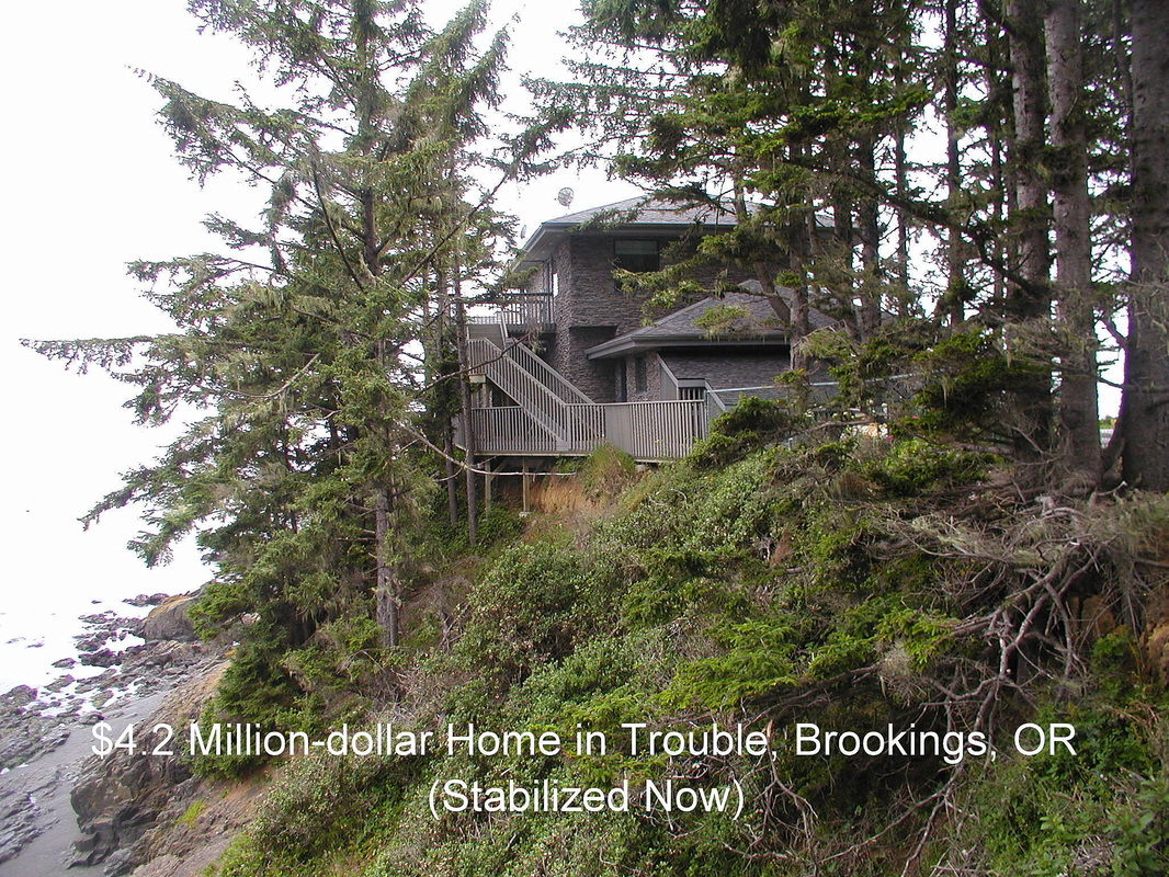
The Four-Million Dollar Home. Harbor, OR, is blessed with a spectacular coastline that supports many high-end homes. One of those sits along on a chunk of soil-covered bedrock that is attached to the mainland by a wisp of land attacked by the ocean on both sides. The owner of the property signed a hold-harmless agreement with the County and against the advice of the geologist he had hired, had his contractor construct parts of the home on a shallow foundation that in some locations was as close as three feet from a near-vertical face of soil covering the rock. The risk to these portions of the home was very high. The owner asked us to write a disclosure report that "blessed the property," but this was impossible to do. Instead, after we explained our concerns to him, he hired us to detail the site geology, subcontract a well-known Eureka engineering firm, and together develop a geologically sound structural solution for the most at-risk portions of the mammoth home. We supported W&K's design of additional grade beams and underpinning using paired helical soil anchors (micropiles) and monitored aspects of the construction. At the project's end we could write a disclosure report that "blessed the property" by detaling the site geology and repairs and how the upgraded foundation reduced the risk of damage by landsliding. New owners now occupy the home.
Subdivisions A-Plenty. Over the twenty-five plus years Busch Geotechnical Consultants has been in business we have done many subdivisions. Elsewhere in the web site is a partial list of some of those that have recognizable names. In short, we have supplied reports for subdivision projects in Port Orford, Gold Beach, Brookings, and Harbor, OR, and in Smith River, Crescent City, Trinidad, McKinleyville, Arcata, Eureka, Hydesville, Fortuna, and Rio Dell. A typical report for a subdivision presents an assessment of the target foundationbearing soils, regional and site-specific geologic hazards and risks, road alignment concerns, setback issues, and leachfield suitability or utilities corridor concerns. To date we have worked on subdivisions ranging in size from a minor partition (a lot split) to an 8,000-acre project on Berry Summit in Humboldt County. We have also evaluated existing subdivison lots for lenders and potential buyers, in effect supplying information to support property evaluations or purchase decisions.
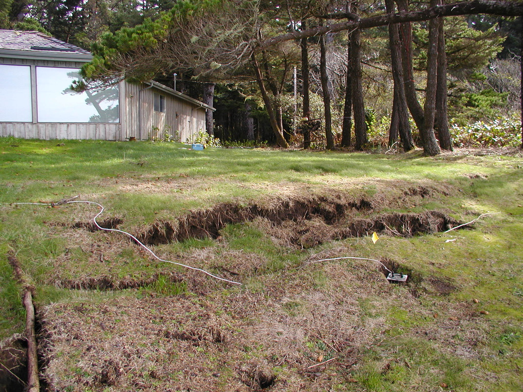
Building on Topsoil. Staff geologists have seen many different types of ground cracks under homes: ones caused by ongoing slope failures that are pulling the ground apart, ones caused by deep fills settling differentially, and ones caused by the consolidation of topsoils. One house stands out among many. Located in Coquille, OR, the house was designed and owner-built, but without the benefit of a geologic investigation or engineering support. Whereas the foundation design would have worked admirably well on a property with little to not topsoil, the Coquille site had about two-and-a-half feet of expansive topsoil. The owners' contractor poured the foundation when the soil was wet, and as it dried it shrank, consolidated, and cracked, caused great structural distress in the home superstructure. Even worse, the designer positioned a load-bearing foundation a few inches behind the face of a cutbank excavated into the weak topsoils. The predictable result: Worse settlement and consolidation-induced cracking of the part of the home above the cutbank than elsewhere. There was no easy fix: the recommended repair required re-engineering the foundation to handle the loads.
A Seacliff Erosion Rate Beyond the Norm. In 1998 we provided a disclosure report to potential purchasers of a bluff-top home on the extreme southern end of the strand of beach in Nesika Beach, OR. We based our conclusions on interviews with the seller, an elderly widow who had lived on the property for decades, on sequential historic aerial photographs, and on published reports by other geologists who had studied the region over time. Sadly, all lines of evidence led to an incorrect prediction: Instead of the anticipated ~1 to ~2 ft per year of erosion and an estimated ~30 years before the home would have to be moved, the site experienced an erosion rate well above normal, averaging up to ~8 ft/yr for short episodes. As part of our monitoring work we placed a series of tiltmeters between the home and the coastline, and over about 8 years we monitored changes in the slope (tilt) of the ground and the distance from the home to the active bluff edge. One by one the tiltmeters tilted ever more strongly and the ground cracks appeared ever closer to the home. We repeatedly tied a rope on the tiltmeter closest to the bluff edge, as one-by-one the devices began sliding down into the ocean. Eventually, the homeowners decided to build a new home, salvaging what they could from the at-risk one. They set the new home well back from the exceptionally rapidly eroding seacliff. The gallery in this web site contains a series of captioned photos of this site showing the progression of the erosion through time.
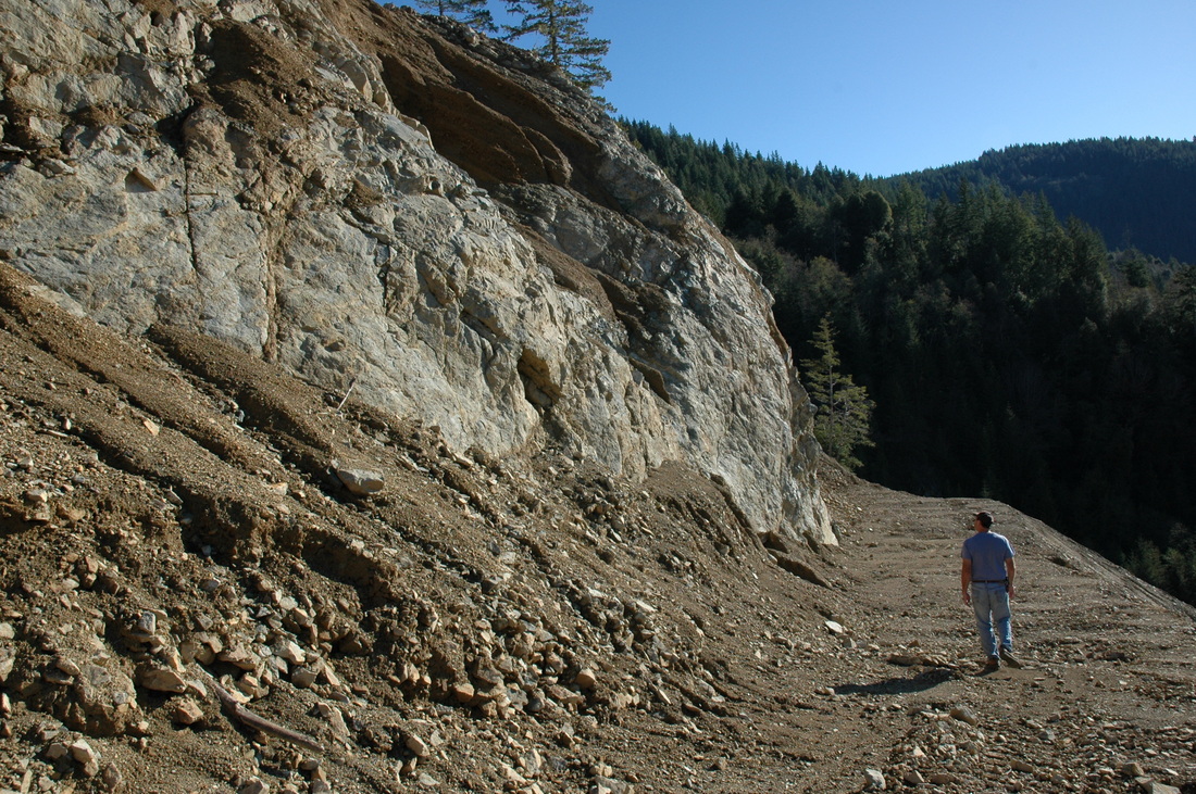
A Growing Quarry. In 1997, the owners of a decades-old quarry near Gasquet, CA, hired Busch Geotechnical to conduct an investigation and provide a report that would support their application to re-open the quarry. BGC reviewed aerial photographs, old mine documents and test results, and traversed the quarry mapping landforms of importance on a detailed topographic base map we had had prepared for the purpose. We issued our report, the quarry reopened, and from 2001 through 2013 we conducted annual or biannual inspections on behalf of the owners so they can remain in compliance, control the operator's activities, and insure that adequate erosion-control structures are in place. Because of effective best management practices by the operators, the quarry, which is in the Smith River watershed, has not shed sediment into the river. In addition to our other work, the quarry operators had BGC produce a topographic base map of another large part of the property to provide an area that Del Norte County, private contractors, or CalTrans could use as spoils storage site. Spoils storage has not begun.
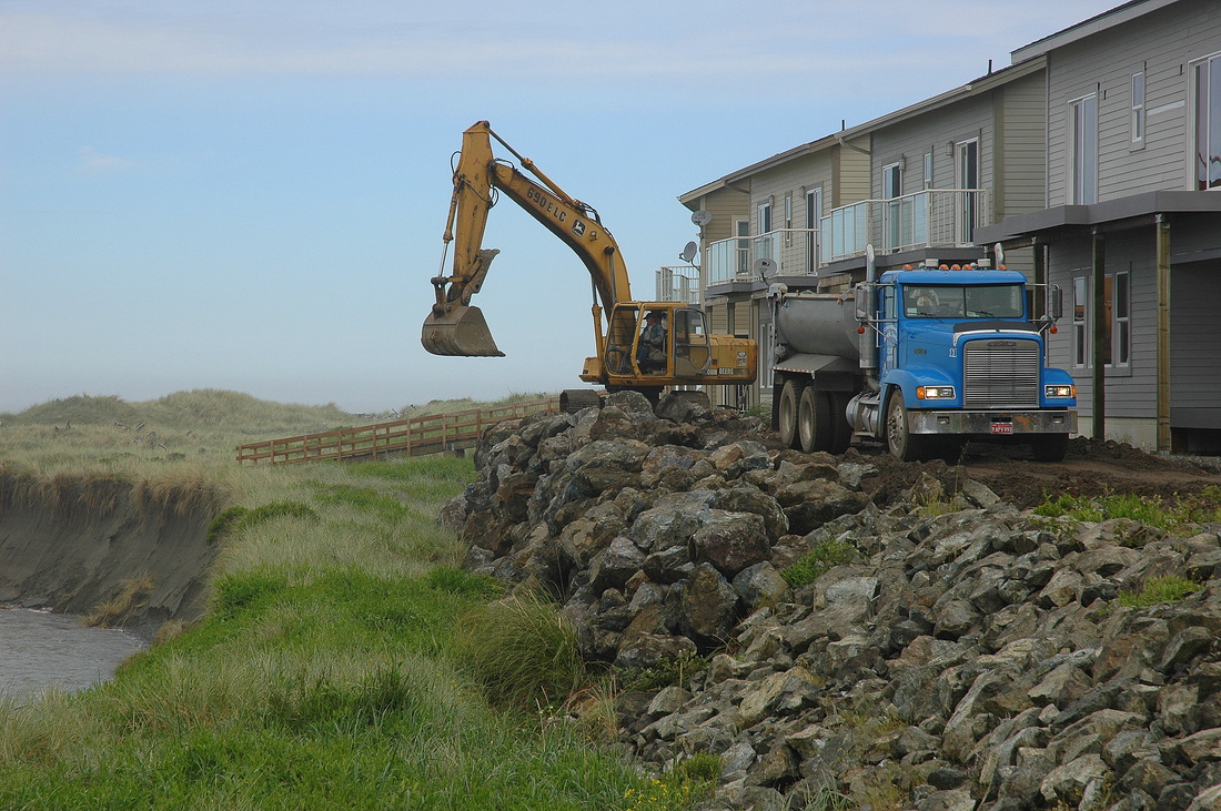
Condos By The Sea. In 2003 an out-of-area developer hired a project engineer to support his plan to build condomiums on a back-beach area in Gold Beach, OR. The engineer hired BGC in a highly limited capacity to subcontract a Cone Penetrometer Testing company to explore the site. BGC monitored the CPT work and provided the logs to the engineer. Later, when requested, we recommended several types of shoreline protective structures that could minimize the risk of damage to the units by marine erosion. One of our suggested structures was based on the successful CalTrans shoreline protective structure at the south end of Clam Beach in Humboldt County, CA. The condos were built (without the issuance of any geotechnical report) and in 2010, freakish late spring and early summer rains caused the mouth of Hunter Creek to migrate north, past the condos. Marine waves entered the mouth and rapidly eroded the dune-fronted shoreline. The developer hired BGC to monitor aspects of a contractor's emergency placement of boulder rip-rap on top of the existing protective structure. Erosion ensued, some boulders rolled down onto the beach at the river's edge, but to date, no unit has been damaged. Nevertheless, a group of owners has filed suit against multiple firms and inviduals. BGC issued no report and had no design responsibility and--thankfully--was not named in the suit. That suit has settled.
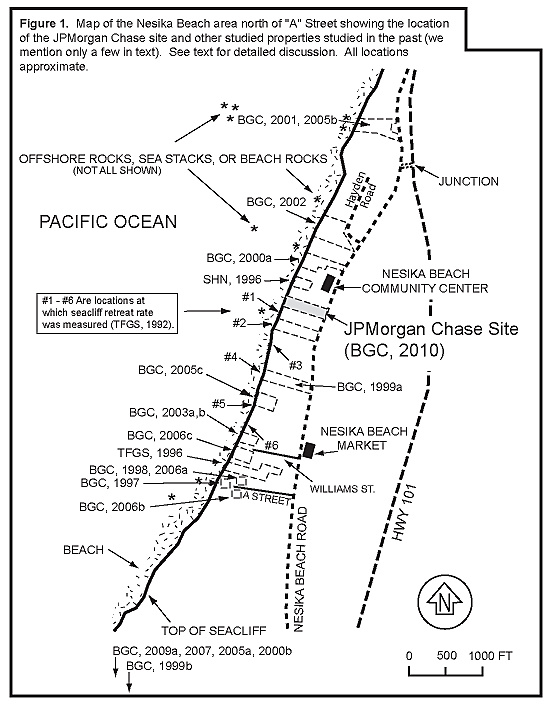
A Case History in the Making. The entire Neska Beach shoreline, whch is about 7 miles north of Gold Beach in Curry Co., OR, is a case history in the making. In the mid1990s a local geologist determined the erosion rate at six specific locations (by reviewing sequential stereo pairs of aerial photographs). Beginning in the late 1990s, BGC geologists began remeasuring the distance from a fixed improvement to the top of bluff in numerous specific locations. In 2004, the Department of Geology and Mineral Industries (DOGAMI) issued a special report on the Nesika beach area. The report authors based their conclusions on a review of stereo pairs of aerial photographs, survey data, and other measurements. The report placed Nesika Beach in a hazard zone and recommended minimum setbacks for new construction. The report also published erosion rates for the bedrock base-of-bluff and the sand top-of-bluff for several strands. The arrow associated with each reference (e.g., BGC, 2000a) points to a particular site we studied. Many of these reports provide erosion-rate estimates or conclusions as well as site-specific geologic information about the nature of the bluff stratigraphy at the site.